IUCN/SSC Otter Specialist Group Bulletin

©IUCN/SCC Otter Specialist Group
Volume 38 Issue 5 (December 2021)
Citation: Shrestha, M.B., Shrestha, G., Reule, S., Oli, S., Tripathi, D.M., and Savage, M. (2021). Otter Survey along the Sanibheri River and its Tributaries, the Pelma and Utterganga Rivers in Rukum District, Western Nepal IUCN Otter Spec. Group Bull. 38 (5): 267 - 278
Otter Survey along the Sanibheri River and its Tributaries, the Pelma and Utterganga Rivers in Rukum District, Western Nepal
Mohan Bikram Shrestha1*, Ganga Shrestha2, Swabhiman Reule3, Sundar Oli3, Devesh Mani Tripathi4, and Melissa Savage5
1
Wildlife Research & Education Network, Nepal Email: shrmohan5@gmail.com
2
Central Department of Environmental Science-Tribhuvan University, Nepal
2Kathmandu Forestry College, Nepal
4Department of Forest and Soil Conservation, Nepal
5University of California, Los Angeles, USA
*Corresponding Author
(Received 22nd January 2021, accepted 20th June 2021)
Abstract: The distribution of three Otter species purported to occur in Nepal is poorly documented. A survey was conducted to document otter sign and habitat parameters of the Sanibheri River and its upstream tributaries, the Pelma River and Utterganga River in Rukum District, Western Nepal. The survey was conducted in the mid-hills region, on an elevation gradient from 747-2159 m asl. Otter scats were observed at 109 sites in 27 of the 71 study transects, and used as a proxy for otter presence. Otter scats were recorded in the narrow river valley of the upper swiftly flowing tributaries, as well as on the limited narrow banks of river at the lower stretches. Scat density was 2.67 scat km-1, 2.38 scat km-1 and 1.14 scat km-1 for the Utterganga River, Pelma River and Sanibheri River respectively. Bank substrate was almost equally divided between boulders (27%), large stones (22%), small stones (26%) and sand and mud (24%). Low levels of human disturbance were recorded along 18% of the river, while 43% and 15% were lightly or moderately disturbed, and 17% was severely disturbed. Otter sign was scarce, but found throughout the study rivers.
Keywords: Otters, Rukum District, Nepal
INTRODUCTION
Three species of otters, Smooth-coated otter (Lutrogale perspicillata), Asian small-clawed otter (Aonyx cinereus) and Eurasian otter (Lutra lutra), were historically reported to be present in Nepal (Hodgson, 1839). But apparently, at the present time, researchers have reliably confirmed only a small population of Smooth-coated otters in Nepal. Neither Eurasian otters nor Asian small-clawed otter have been observed in the wild for many years.
The Smooth-coated otter was reported from the major river basins of Nepal, the Koshi, Narayani, Karnali and Mahakali Rivers until several decades ago (Shrestha, 2003). But recently, only a small, isolated population of Smooth-coated otter is known to occur in the southwestern wetlands, primarily restricted to protected areas, i.e., Bardia National Park and Suklaphanta National Park (Acharya, 2017; Bhandari, 2019; Thapa, 2020).
Eurasian otter presence was believed to occur in mountain streams and rivers across Nepal (Acharya, 2006) with an estimated population range of 1000-4000 (Jnawali et al., 2011). The species was reported from Rara Lake of Rara National Park (Bolton, 1976) and from Begnas and Rupa Lakes in the Pokhara Valley in 1991 with photographic evidence (Acharya and Gurung 1994). But a study conducted in 2008 by Bhandari and Bijaya, (2008) found no remaining otters in Begnas and Rupa Lakes. The Biodiversity Profile Project (1996) suggested the presence of Eurasian otter in Annapurna Conservation Area, Makalu Braun National Park, Lake Rara National Park, Bardia National Park and districts of Saptari, Chitwan, Kapilvastu, Bardia, Kailali, Kanchanpur, Bajhang, Bajura, Ilam, Panchthar, Taplejung and Sankhuwasabha; same year from Kanchenjunga region (Yonzon, 1996). Shrestha (1997) reported Eurasian otter presence in eight districts in the Terai and 13 districts in the hilly region, but without the specific locations; Yonzon (1998) reported presence in West Seti River; Ghodaghodi Lake of Kailali district (Kafle, 2007); streams and streamlets in Pyaudikhola watershed and Kapringkhola watershed of Gorkha District (Kafle, 2011). All of these studies, however, were based on key informant interviews or observations of local villagers, and lacked confirmation. Basnet et al. (2020) conducted a literature review of reports of Eurasian otters in Nepal, and concluded that there have been no reports of the species in the country since 1991 that have been substantiated by photographs or genetic analysis, throwing into question prior estimates of Eurasian otter presence.
Likewise, Hodgson (1839) mentioned the presence of the Small-clawed otter in Nepal but recorded no specific location (Acharya and Rajbhandari, 2011), and there has been no documented evidence of the species presence since.
The decline of otter species in Nepal is linked to natural habitat degradation (extraction of sand and stones from river banks, shoreline vegetation removal, industrial and agricultural pollution,) reduced food availability due to overfishing and prey species poisoning, human intrusion in river banks for settlement, livestock grazing and dam construction (Acharya and Gurung, 1994; Acharya, 2006; Acharya and Lamsal, 2010; Acharya and Rajbhandari, 2011), and retaliatory killings over fish predation (Bhandari and Bijaya, 2008). The illegal trade in otter pelts is also a current threat; Savage and Shrestha (2018) reported a total of 755 otter pelts seized in Nepal in between1989 -2017. Thus, status of otters in Nepal is ambiguous and lacks proper documentation of its distribution and species identity (Acharya and Rajbhandari, 2011).
This study presents data on otter distribution and habitat along the Sanibheri River and its upstream tributaries, the Pelma River and Utterganga River, in Rukum East and Rukum West Districts, Western Nepal. The study had three objectives: 1) to document the distribution of otters in the Sanibheri River and its tributaries, 2) to characterize habitat parameters along the study rivers and, 3) to describe potential threats to otters in the study area.
STUDY AREA
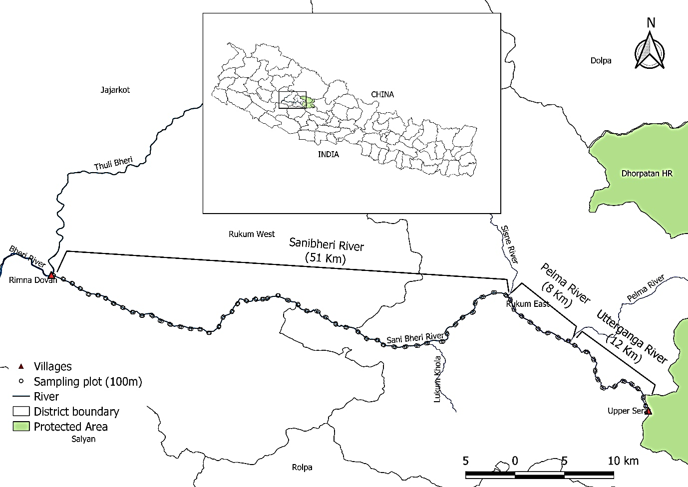
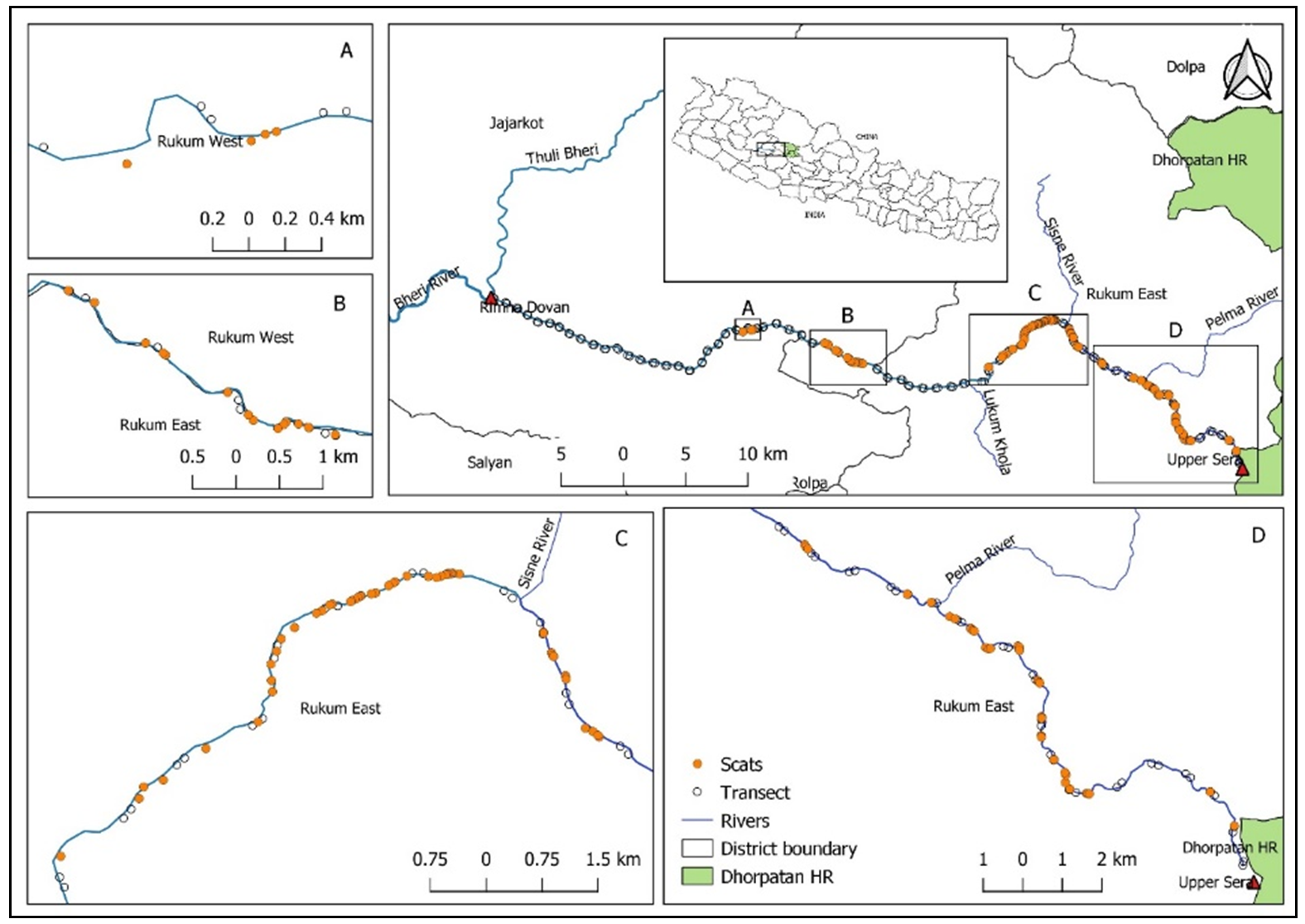
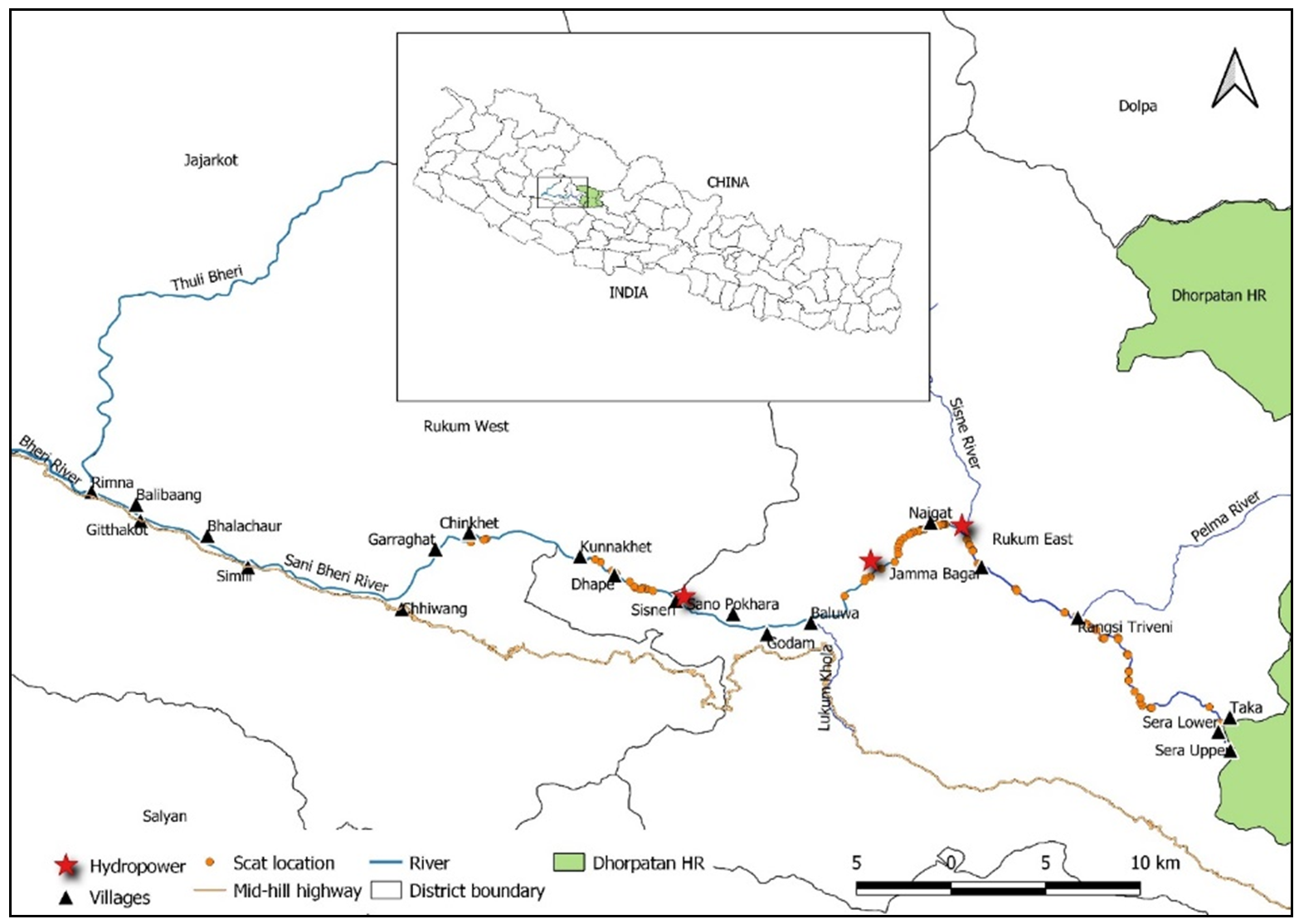
The study was conducted on three rivers, the mainstream Sanibheri Bheri and two upstream tributaries, the Pelma River and Utterganga River, based on the quality of potential otter habitat assessed during a reconnaissance field study. The Utterganga River originates in the Dhorpatan Hunting Reserve and flows into the Pelma River which in turn flows into the Sisne River, and then into the Sanibheri River. Farther downstream, the Sanibheri River and Thulibheri River join to form the Bheri River. This study was carried out from Rimnaghat (28.693301°N 82.279888°’E; 747 m asl), at the confluence of the Sanibheri and Thulibheri Rivers, continuing east to the Utterganga River and the Upper Sera hinterland (28.573783°N 82.818617°E; 2159 m asl), at the edge of the Dhorpatan Hunting Reserve. The survey covered stretches of potential otter habitat, 71 km of river, including the entire Sanibheri River stretch (51 km), 8 km of Pelma River, and 12 km of Utterganga River (Fig. 1).
METHODS
Field surveys of otters often rely on the observation of tracks, scat, latrines, prey remains and dens (Mason and Macdonald, 1987; Macdonald, 1990; Wilson and Delahay, 2001). Scat distribution is here used as a proxy for otter distribution (Reuther et al., 2000; Sittenthaler et al., 2020).
A survey for otter sign was conducted for 17 days in October, 2019, after the monsoon, when water levels in the rivers drop, leaving mud and sand banks exposed to record otter sign. The entire study rivers length (71 km) was divided into 1 km transects placed along one riverbank (Jamwal et al. 2016). One plot was placed at the start of each transect, measuring 100 m (along the riverbank) by 10 m (away from the river’s edge) for a total of 71 plots. Otter scat was recorded in each plot. In addition, because otter scat was scarce, it was also recorded whenever encountered along the transect, unless precluded by inaccessible terrain.
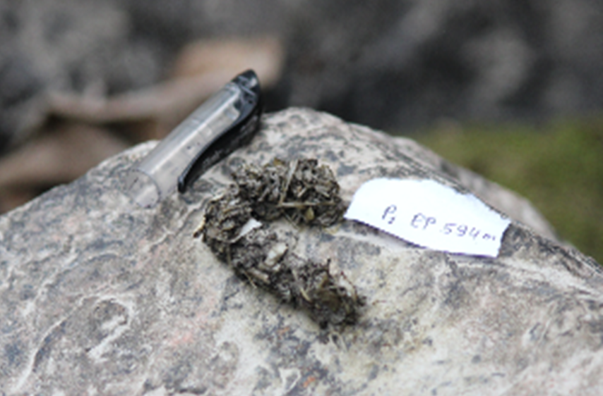
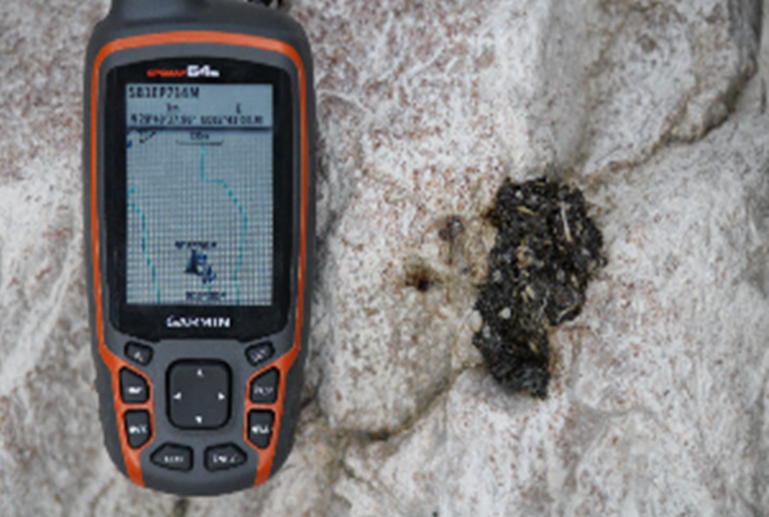
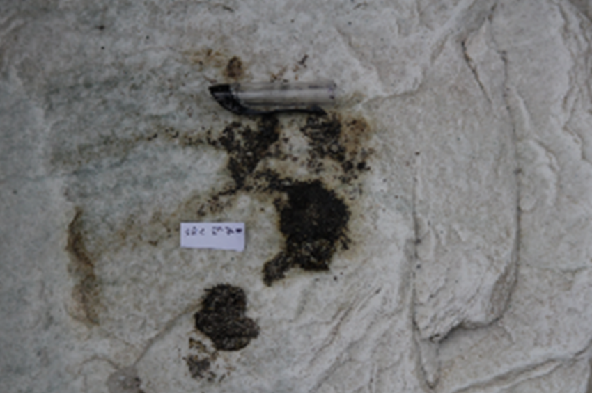
A plot or transect with presence of otter scat was defined as an “otter positive” site. Scat was identified by prey species remnants (fragments of fish, frog or crab), and a fishy odor (Macdonald, 1990) and photographs of scats were confirmed by research specialists at the IUCN Otter Specialist Group. Scats were recorded separately when more than 5 m apart (Melquist and Hornocker, 1983; Newman and Griffin, 1994). In a few sites, there were deposits of several scat, but since it was unclear if they represented an otter latrine, these were recorded as a single occurrence. An abundance of tracks, especially dog tracks, made it difficult to confirm tracks as otter. Each scat location was marked by GPS, retrieved in Quantum Geographical Information System (QGIS) and a distribution map was produced.
Habitat variables were also recorded in each plot. River width, or distance between banks, was visually estimated in the field due to the lack of a range finder, but later validated using Google Earth. Bank slope was measured with a clinometer (Nawab and Hussain, 2012). Mean vegetation cover and mean substrate attributes were calculated by averaging the midpoint of each percent category. Habitat was characterized in categories by: 1) percent vegetation cover, and 2) percent bankside substrata. Vegetation was estimated by percent cover class, 1) 0-5% or nearly bare, 2) 5-25% or lightly vegetated 3) 25-50% or moderately vegetated, 4) 50-75% or mostly vegetated and, 5) 75-100% or heavily vegetated. Substrate attributes were binned by diameter category as 1) sand (< 5 mm), 2) pebbles (5 mm-5 cm), 3) small stones (5-50 cm), 4) large stones (50-100 cm), and 5) boulders (>100 cm) (total percentage may not equal 100% because of use of mid-points of values in calculations). Habitat disturbance (abundance of dog and cow tracks, trash, and proximity to houses) was recorded as none, light, moderate or severe (Jamwal et al. 2016). Potential threats (habitat loss/fragmentation, excavation and mining, infrastructure development, human disturbance and water quality) were noted and broadly characterized.
Since few scats were observed in the plots, scat density per kilometer (scat km-1) was calculated for each study river stretch separately (Table 1). Total scat recorded throughout the study rivers was correlated against bank substrate parameters and vegetation cover using Pearson’s correlation test.
RESULTS AND DISCUSSION
Spatial Distribution of Scats
Most otter species are difficult to observe (Mason and Macdonald, 1986; Macdonald, 1990) and field surveys are frequently based on observed otter sign, usually on the presence of scat (Macdonald, 1990). Even though the validity through tracks and scats have been questioned and number of otter sign is not easily translated into a measure of abundance, scat is a useful marker for studying otter presence and distribution (Ruiz-Olmo and Gosálbez, 1997). No direct observation of otters was made during the survey, and scat is the only otter sign reported here (Fig. 2). Along the 71 km of riverbank surveyed, scats were recorded at 109 sites in 27 transects. The remaining 44 transects were devoid of scat or other otter sign. Thirty-eight % of the transects were thus otter positive and 62% otter negative. Of the 109 scats counted, only 3 scats were observed in the plots and 106 scats, were observed outside the plot in the transects. Of the 109 scats, 58 (53%) were located on the banks of the Sanibheri River, 19 (17%) along the Pelma River and 32 (29%) along the Utterganga River. The scat density along Utterganga River (2.67 scat km-1) and Pelma River (2.38 scat km-1), were both somewhat higher than along the Sanibheri River (1.14 scat km-1) (Table 1). While the data gives some indication of the distribution of otters, no direct relationship can be assumed between number of scat and the number of animals present, although higher scat density does suggest more otters present.
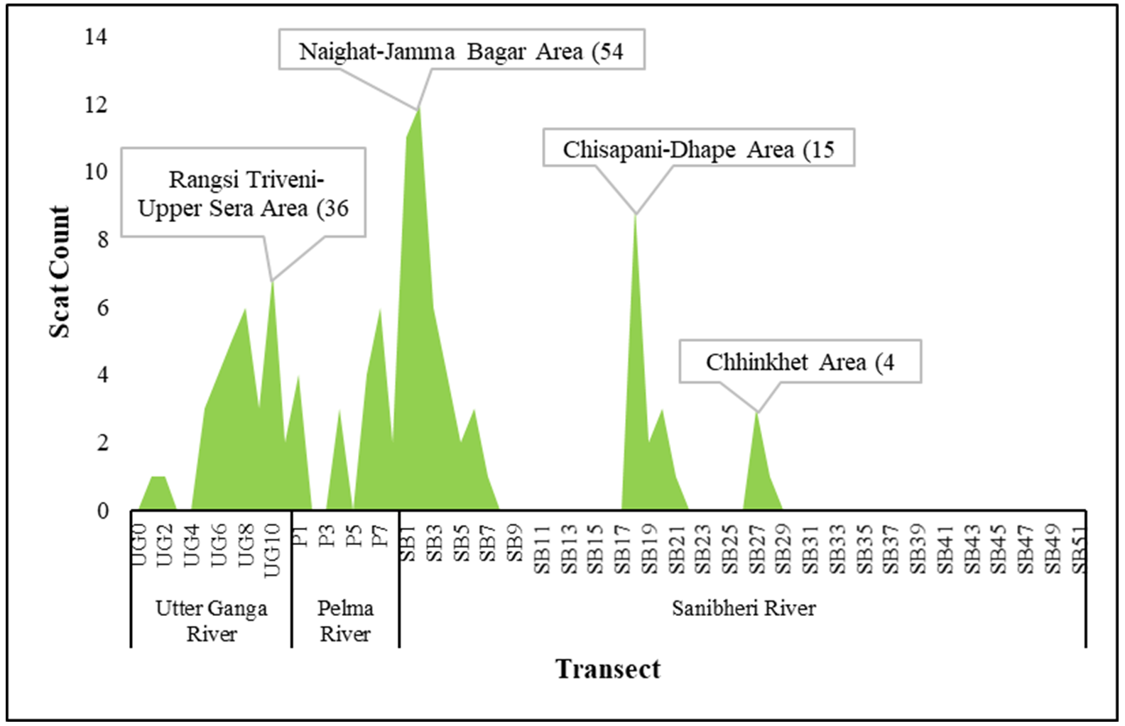
Along the downstream reach, scat distribution was absent or irregular and disjunctive. Scats in the Chhinkhet area (A in Fig. 3) and Chisapani-Dhape area (B in Fig. 3) were scarce, with 4 scats in 2 km of river (Transects SB27 & SB28 in Fig. 4) and 15 scats in the 4 km of river (Transects SB18 - SB21 in Fig. 4) in Chisapani-Dhape area. Fewer otter signs may be found where populations are at low levels or fragmented (Macdonald, 1990) as in the Chinkhet and Chisapani-Dhape areas.
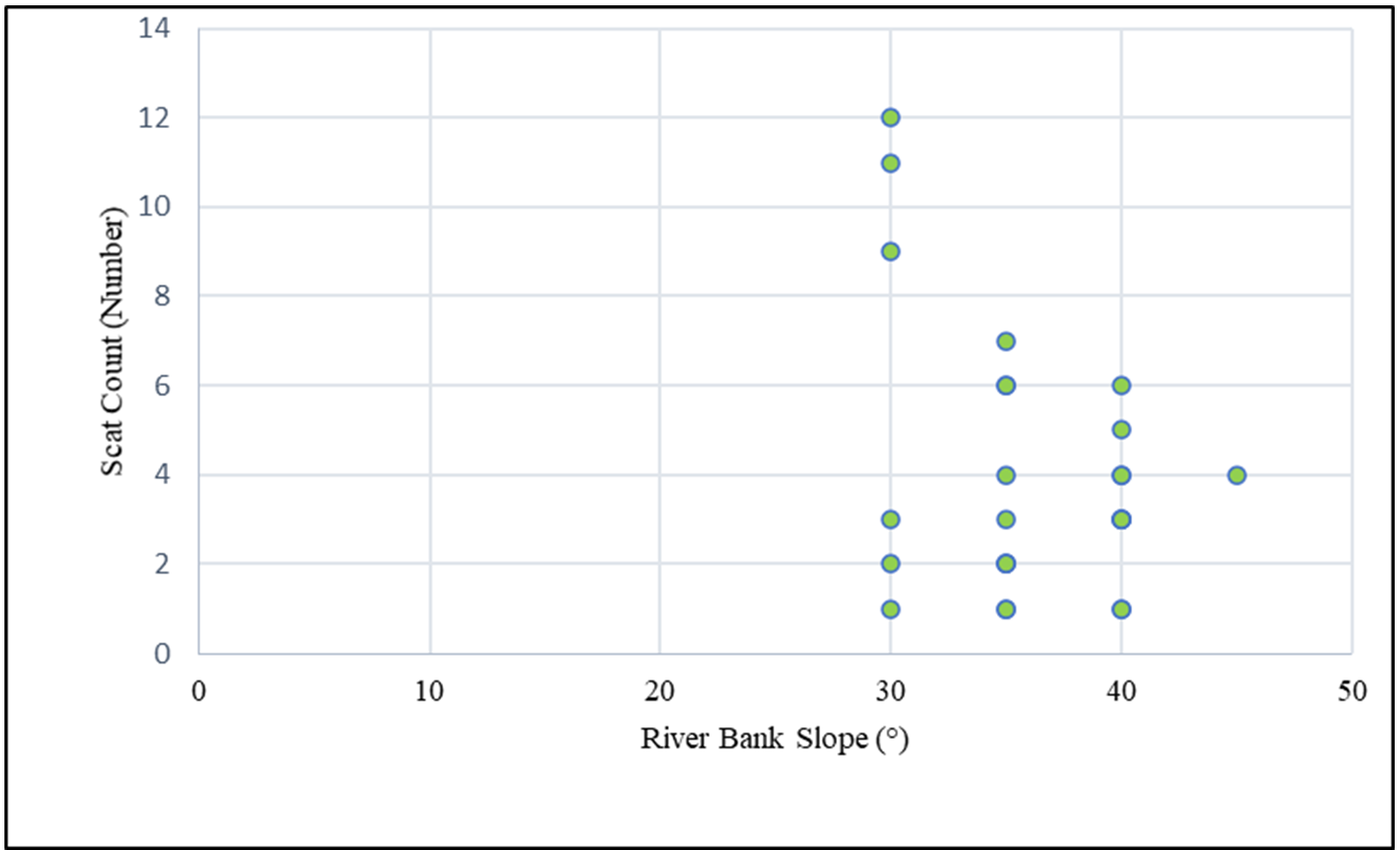
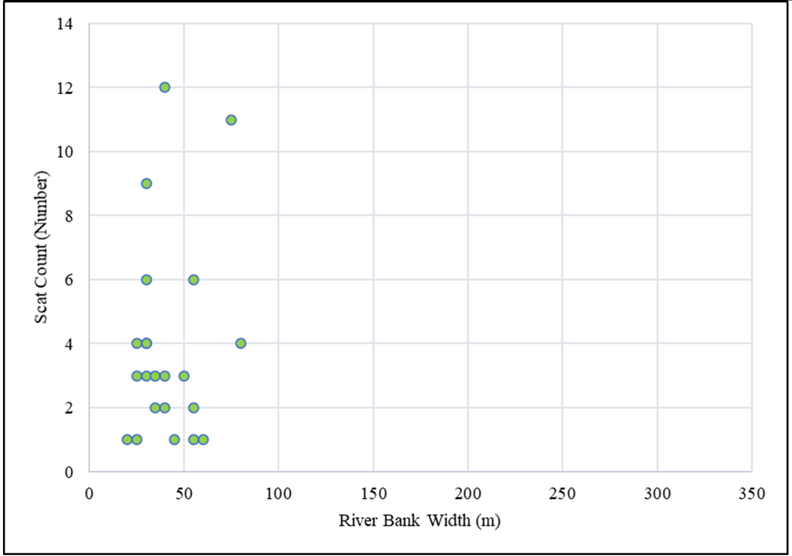
Scats were relatively more numerous in the upstream reaches. A total of 54 scats were found between the Naighat-Jamma Bagar area (C in Fig. 3) from the 11 km river segment (Transect P4, P6-P8 & SB1-SB7 in Fig. 3) with the most concentrated scats at the Naighat area (Transects-SB1, SB2 & SB3 in Fig. 3). Further upstream, 36 scats were found between the Rangsi Triveni-Upper Sera area (Box-D in Fig. 3) from 10 km (transects P1, UG1, UG2 & UG5-UG11 in Fig. 4). Scats along the surveyed rivers were most abundant in areas with precipitous geographic terrain that constrained the swiftly flowing river into a narrow valley with bank slopes between 30-40° and riverbanks width between 20-80 m (Fig. 5).
The survey recorded scats from 914 m asl in Chinkhet area to 2123 m asl in the Taka area (between 747-2159 m asl). Half of all scats were found between 1280-1491m asl; the other half were sparsely distributed between 975-1280m asl or 1491-1768m asl. No scats were found in the lower elevation below 975 m and above 1768 m.
Habitat Parameter Characteristics
The river width in the lower stretches was significantly wider than in the upper stretches, varying from 20m to 320m, with about half of the river width ranging between 35-180m. A quarter of the rest of the river ranged between 20-35m and the remaining quarter between 180-320m. Riverbank slope varied from 15° to 45° with about half between 20°-35°. A quarter of the rest of the bank slope was between 15°- 20° and the remaining quarter between 35°- 45°.
Bank vegetation ranged from subtropical plant species along the downstream stretches and temperate vegetation upstream. Downstream vegetation was dominated by Shorea robusta, Acacia catechu, Dalbergia sissoo, Sapium insigne, Eupatorium adenophorum., Diploknema butyraceae, and Imperita cylindrica; upstream vegetation included Woodifordia fruticosa, Albizia procera., Pinus roxburghii, Schima wallichhi, Ficus semicordata, Debregaesia longifolia. Himalayacalamus asper, and Salix sp. A majority (65%) of the banks of the entire study area is nearly bare, 26% is lightly vegetated, and 9% is moderately vegetated. Bank substrate percentages were: 24% sand and mud, 26% small stones, 22% large stones and 27% boulders. Human disturbance was estimated as: 18% none, 43% light, 15% moderate, and 17% severe.
Otters are sensitive to habitat characteristics (Hung and Law, 2016). Throughout the study area, otter scats were positively correlated with large flat rock and boulders (r=0.69, P<0.05) (Table 2). Otters prefer sites with vegetation or large boulders for protected resting sites and large flat rocks on which they consume their prey (Jamwal et al., 2016). Chettri and Savage (2014) noted positive correlation of otter sign with boulders (r=0.94) and with vegetation (r=0.52). But this study obtained a weak correlation between scats and vegetation cover (Table 2), perhaps because the majority of riverbank vegetation cover is nearly bare.
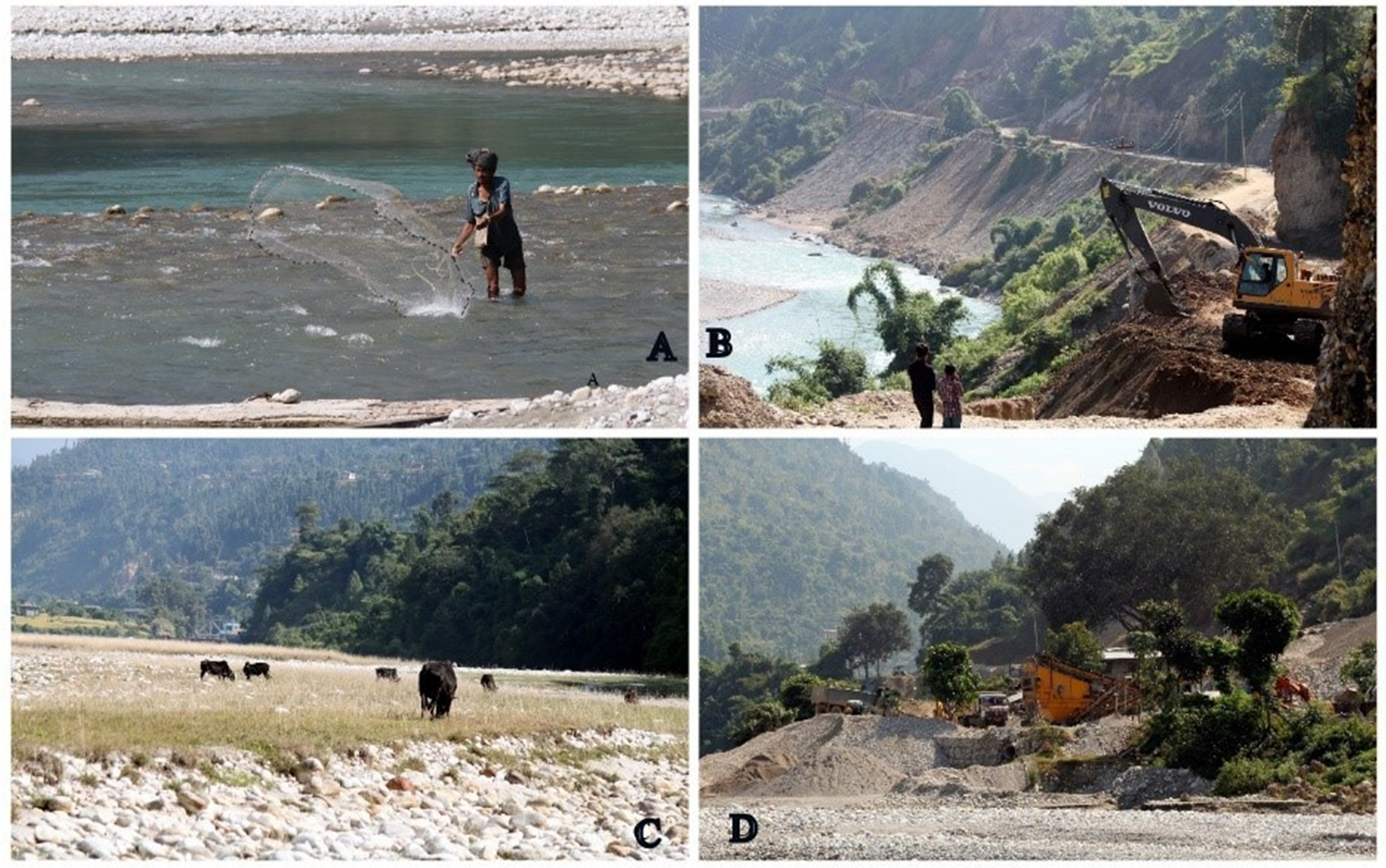
Human disturbance can play an important role in the distribution of otters. The upstream reaches of the Sanibheri River watershed are relatively undisturbed, and human settlement is sparse and distant from the river (Fig. 6). In contrast, the downstream stretches are characterized by a wide valley, with a meandering, low-velocity river divided into braided channels. Human settlements are common in the flat terrain, as is development, including the ongoing construction of a highway adjacent to the riverbank. Dirt and gravel are dumped onto the riverbanks, degrading water quality and burying otter habitat. Mining, fishing and grazing are also more common in the downstream reaches (Fig. 7). Planned hydropower plants are a threat to otter survival on the upper stretches. Thus far, three hydropower projects have been approved for construction in Sanibheri River by Department of Electricity Development, Nepal (DoED, 2021). Local villagers also report that otter habitat may be affected by the occasional shifting of the river course.
Along the Sanibheri River and its upstream tributaries, the Pelma and Utterganga Rivers, observation of otter scat suggests the presence of otter in all three rivers. Scats observed along the upstream reaches were frequent, whereas scats along the downstream reaches were disjunctive or absent. Human disturbance appears to have affected the suitability of the habitat of the lower stretches, while the upper stretches appear to offer better otter habitat. Habitat destruction, fishing intensity, mining, road construction, and possibly low prey abundance appears to limit otter populations along these rivers, particularly in the downstream reaches. The otter species present was not identified, but the elevation and fast-flowing river current suggests that the species may be Eurasian otters (Harris, 1968; Mitchell, 1977; Foster-Turley et al., 1990). Genetic analysis of scats is needed to confirm the species found in this study area.
Acknowledgements: We are grateful to the Nepal Department of Forest and Soil Conservation for permission to conduct this study. We thank Nicole Duplaix and Tom Serfass for identification of otter scats, and the IUCN/SSC Otter Specialist Group for financial support.
REFERENCES
Acharya, P.M. (2006). Otter and Wetland Conservation in Nepal. In Rimal, N.N. (Eds.). Water Resources, Security, SEEP Water, Kathmandu: 144-149.
Acharya, P.M. (2017). Status of Smooth-coated Otter Lutrogale perspicillata (Geoffroy, 1826) in the Khauraha River of Bardia National Park, Nepal. Otter, J. of the Int’l. Otter Survival Fund, 3: 23-27.
Acharya, P.M. Gurung, J.B. (1994). A Report on the Status of Common Otter (Lutra lutra) in Rupa and Begnas Tal, Pokhara Valley, Tiger Paper Regional Quarterly Bulletin on Wildlife and National Parks Management, V. XXI: No. 2: 21-24.
Acharya P. and Lamsal P. (2010). A survey for smooth-coated otter Lutrogale perspicillata on the river Narayani, Chitwan Nartional Park, Nepal. Hystrix It. J. Mamm., 21(2): 199-202.
Acharya, P., Rajbhandari, S.L. (2011). Status of Otters in Nepal. Report Submitted to IUCN/SSC Asian Secretariat, Sri Lanka.
Basnet, A., Bist, B.S., Ghimire, P. Acharya, P.M. (2020). Eurasian Otter (Lutra lutra): Exploring Evidence in Nepal. IUCN Otter Spec. Group Bull. 37 (1): 29-37.
Bhandari, J. (2019). Conservation Status Survey and Awareness of Smooth-coated Otters in Babai River of Bardia National Park, Nepal. A Final Research Report Submitted to The Rufford Small Grant Foundation. UK.
Bhandari, J., Bijaya, D.G.C. (2008). Preliminary survey and awareness for otter conservation in Rupa Lake, Pokhara, Nepal. Journal of Wetlands Ecology. 1(1/2): 2.
Bolton M. (1976). Lake Rara National Park Management Plan 1976-81. Project Working Document No. 3. HMG/UNDP/FAO Project: FAO/NEP/72/002. Kathmandu. 70 pp.
Biodiversity Profile Project ( BPP). (1995). Enumeration of the Mammals of Nepal. Biodiversity Profiles Project. Technical Publication No. 6. Department of National Parks and Wildlife Conservation. Kathmandu. 86 pp.
Chettri, P., Savage, M. (2014). A Distribution Survey for Otters along a River in Central Bhutan. IUCN Otter Spec. Group Bull. 31(2): 65-74. https://www.iucnosgbull.org/Volume31/Chettri_Savage_2014.html
DoED (2021). Department of Electricity Development, Survey license: Hydro (more than 1MW). https://www.doed.gov.np/license/13; adopted on: January 15, 2021
Foster-Turley, P.A., Macdonald, S., and Mason, C. (1990). Otters: An Action Plan for Their Conservation, IUCN, Gland, Switzerland. DOI https://doi.org/10.2305/IUCN.CH.1990.SSC-AP.3.en
Harris, C. (1968). Otters: A study of the recent Lutrinae. Weidenfeld and Nicolson, London, United Kingdom.
Hodgson, B.H. (1839). Summary description of four new species of otter. J. Asian Soc. of Ben. 8: 319-320.
Hung, N. and Law, C.H. (2016). Lutra lutra (Carnivora: Mustelidae). Mammalian Species 48(940): 109-122.
Jamwal, P.S., Takpa, J., Chandan, P, Savage, M. (2016). First systematic survey for otter (Lutra lutra) in Ladakh, Indian Trans Himalayas. IUCN Otter Spec. Group Bull. 33(2): 79-85. https://www.iucnosgbull.org/Volume33/Jamwal_et_al_2016.html
Jnawali, S.R., Baral, H.S., Lee, S., Acharya, K.P., Upadhyay, G.P., Pandey, M., Shrestha, R., Joshi, D., Laminchhane, B.R., Griffiths, J., Khatiwada, A. P., Subedi, N., Amin, R. (compilers) (2011). The Status of Nepal Mammals: The National Red List Series, Department of National Parks and Wildlife Conservation, Kathmandu, Nepal.
Kafle, G. (2007). Status and conservation of Ramsar sites and associated biodiversity in Nepal with emphasis on Ghodaghodi Lake Area. A MSc. Thesis submitted to Institute of Forestry, Pokhara, Nepal.
Kafle, G. (2011). Otter Research and Conservation Project in Wetlands of High Hills, Nepal. A Research Report submitted to The Rufford Small Grants Foundation, United Kingdom. 9 pp.
Macdonald, S. (1990). Surveys. In: Foster-Turley, P., Macdonald, S. M., Mason, C.F. (Eds.). Otters: An Action Plan for their Conservation. IUCN/Otter Specialist Group, Gland. Pp. 8-10.
Mason, C. and Macdonald, S.M. (1986). Otters: Ecology and Conservation. Cambridge University Press, Cambridge. 248 pp.
Mason, C. and Macdonald, S.M. (1987). The use of scats for surveying otter (Lutra lutra) populations: An evaluation. Biol. Cons. 41(3): 167-177.
Melquist, W.E., Hornocker, M.G. (1983). Ecology of river otters in west central Idaho. Wildlife Monographs 83: 1-60.
Mitchell, R.M. (1977). Accounts of Nepalese mammals and analysis of the host-ectoparasite data by computer techniques. Retrospective Theses and Dissertations. 7626.
https://dr.lib.iastate.edu/handle/20.500.12876/80524 Iowa State University.
Nawab, A., Hussain, S.A. (2012). Factors affecting the occurrence of smooth-coated otter in aquatic system of the Upper Gangetic Plains, India. Aquatic Conserv. 2(5): 616-625. doi: https://doi.org/10.1002/aqc.2253 .
Newman., D., Griffin, C.R. (1994). Wetland use by river otters in Massachusetts. J. of Wildlife Mgmt. 58(1): 18-23.
Reuther, C., Dolch, D., Green, R., Jahrl, J., Jefferies, D., Krekemeyer, A., Kucerova, M., Madsen, A.B., Romanowski, J., Roche, K., Ruiz-Olmo, J., Teubner, J., Trindada, A. (2000). Surveying and monitoring distribution and population trends of the Eurasian otter (Lutra lutra): guidelines and evaluation of the standard method for surveys as recommended by the European section of the IUCN/SSC Otter Specialist Group. IUCN/SSC OSG. Habitat. 148 pp.
Ruiz-Olmo, J., & Gosálbez, J. (1997). Observations on the sprainting behaviour of the otter Lutra lutra in the NE Spain. Acta Theriologica, 42(3), 259-270.
Savage, M., Shrestha, M.B. (2018). The illegal trade in otter pelts in Nepal. Traffic Bulletin, 30(2): 59-61.
Shrestha, T.K. (1997). Mammals of Nepal with reference to those of India, Bangladesh, Bhutan and Pakistan. Mandela Book. Point, Nepal. 387 pp.
Shrestha, T.K. (2003). Wildlife of Nepal: A Study of Renewable Resources in Nepal, Himalayas. 752 pp.
Sittenthaler, M., Scholl, E.M., Leeb, C., Haring, E., Praz-Follner, R. Hacklander, K. (2020). Marking behavior and census of Eurasian Otters (Lutra lutra) in riverine habitats: What can scat abundances and non-invasive genetic sampling tell us about otter numbers? Mamm. Research 65: 191–202.
Thapa, P. (2020). Distribution and threats to otter in Suklaphanta National Park, Nepal. B.Sc. Thesis Submitted to Institute of Forestry, Pokhara, Nepal.
Wilson, G.J., Delahay, R.J. (2001). A review of methods to estimate the abundance of terrestrial carnivores using field signs and observation. Wildl. Research. 28(2): 151-164.
Yonzon, P. B. (1996). Status of Wildlife in Kanchenjunga Region. A Reconnaissance Report Series 23. Kathmandu and WWF Nepal.
Yonzon, P.B. (1998). Baseline information on wildlife of the west Seti River Valley with emphasis on birds and mammals. A report to the West Seti Hydro-Electric project. SMEC Ltd.
Résumé: Suivi de la Loutre le Long de la Rivière Sanibheri et de ses Affluents, les Rivières Pelma et Utterganga dans le Distrct de Rukum, à l’Ouest du Népal
La répartition de trois espèces de loutres censées se produire au Népal est mal connue. Une étude a été menée pour documenter les indices de présence de loutre et les paramètres de l'habitat de la rivière Sanibheri et de ses affluents en amont, les rivières Pelma et Utterganga dans le district de Rukum, à l'ouest du Népal. Le relevé a été réalisé dans la région des moyennes collines, sur un gradient d'altitude de 747 à 2.159 m. Des épreintes de loutres ont été observées sur 109 sites dans 27 des 71 transects de l'étude, et utilisés comme indicateur de la présence de loutres. Des épreintes de loutres ont été répertoriées dans l'étroite vallée fluviale des affluents supérieurs à courant rapide, ainsi que sur les berges étroites et restreintes de rivière dans les tronçons inférieurs. La densité des épreintes était de 2,67 épreintes par km, 2,38 épreintes par km et 1,14 épreinte par km pour la rivière Utterganga, la rivière Pelma et la rivière Sanibheri respectivement. Le substrat de la berge était réparti de manière presque égale entre rochers (27 %), grosses pierres (22 %), petites pierres (26 %) et sable et boue (24 %). De faibles niveaux de perturbation humaine ont été enregistrés sur 18 % de la rivière, tandis que 43 % et 15 % ont été légèrement ou modérément perturbés, et 17 % ont été gravement perturbés. Les indices de présence de loutre étaient peu nombreux, mais ont été trouvés sur toutes les rivières étudiées.
Revenez au dessus
Resumen: Relevamiento de Nutrias en el Río Sanibheri y sus Tributarios, los Ríos Pelma y Utterganga, en el Distrito de Rukum, Nepal Occidental
La distribución de las tres especies de Nutrias que ocurren en Nepal está pobremente documentada. Condujimos un relevamiento para documentar signos de nutria y parámetros de hábitat en el Río Sanibheri y sus tributarios de la cuenca superior, los Ríos Pelma y Utterganga, en el distrito de Rukum, Nepal. El relevamiento fue conducido en la región de laderas y elevaciones medias, en un gradiente altitudinal de 747-2159 m s.n.m. Fueron observadas fecas de nutrias en 109 sitios, en 27 de las 71 transectas estudiadas, y fueron utilizadas como proxy de la presencia de nutrias. Las fecas ueron registradas en el angosto valle fluvial de los tributarios superiores correntosos, así como en las pocas barrancas angostas del río en los tramos inferiores. La densidad de fecas fue de 2.67 km-1,, 2.38 scat km-1 y 1.14 scat km-1 para los Ríos Utterganga, Pelma y Sanibheri respectivamente. El sustrato en las barrancas estuvo casi igualmente repartio entre grandes bloques de roca (27%), piedras grandes (22%), piedras pequeñas (26%) y arena y barro (24%). Registramos bajos niveles de disturbio humano a lo largo de 18% del río, mientras que 43% y 15% estaban levemente o moderadamente disturbados, y 17% severamente disturbado. Los signos de nutrias fueeron escasos, pero encontrados todo a lo largo de los ríos estudiados.
Vuelva a la tapa


